Mappa dell'oklahoma della valle di pauls Immagini Stock
(49)Filtri rapidi:
Mappa dell'oklahoma della valle di pauls Immagini Stock
 Pauls Valley Oklahoma USA visualizzata su una mappa geografica o su una mappa stradale Foto Stockhttps://www.alamy.it/image-license-details/?v=1https://www.alamy.it/pauls-valley-oklahoma-usa-visualizzata-su-una-mappa-geografica-o-su-una-mappa-stradale-image432579989.html
RM2G3NM59–Pauls Valley Oklahoma USA visualizzata su una mappa geografica o su una mappa stradale
 Pauls Valley è stato puntato su una mappa di Oklahoma, Stati Uniti Foto Stockhttps://www.alamy.it/image-license-details/?v=1https://www.alamy.it/pauls-valley-e-stato-puntato-su-una-mappa-di-oklahoma-stati-uniti-image360219896.html
RF2BX1C48–Pauls Valley è stato puntato su una mappa di Oklahoma, Stati Uniti
 Salutate la usa mini golf, Usa mappa, Lago Winnipesaukee 37133226350 o Foto Stockhttps://www.alamy.it/image-license-details/?v=1https://www.alamy.it/foto-immagine-salutate-la-usa-mini-golf-usa-mappa-lago-winnipesaukee-37133226350-o-171930322.html
RMKYM2TJ–Salutate la usa mini golf, Usa mappa, Lago Winnipesaukee 37133226350 o
 Pauls Valley, Garvin County, Stati Uniti, Stati Uniti, Oklahoma, N 34 44' 24''', S 97 13' 20''', MAP, Cartascapes Map pubblicata nel 2024. Esplora Cartascapes, una mappa che rivela i diversi paesaggi, culture ed ecosistemi della Terra. Viaggia attraverso il tempo e lo spazio, scoprendo l'interconnessione del passato, del presente e del futuro del nostro pianeta. Foto Stockhttps://www.alamy.it/image-license-details/?v=1https://www.alamy.it/pauls-valley-garvin-county-stati-uniti-stati-uniti-oklahoma-n-34-44-24-s-97-13-20-map-cartascapes-map-pubblicata-nel-2024-esplora-cartascapes-una-mappa-che-rivela-i-diversi-paesaggi-culture-ed-ecosistemi-della-terra-viaggia-attraverso-il-tempo-e-lo-spazio-scoprendo-l-interconnessione-del-passato-del-presente-e-del-futuro-del-nostro-pianeta-image621256117.html
RM2Y2MJED–Pauls Valley, Garvin County, Stati Uniti, Stati Uniti, Oklahoma, N 34 44' 24''', S 97 13' 20''', MAP, Cartascapes Map pubblicata nel 2024. Esplora Cartascapes, una mappa che rivela i diversi paesaggi, culture ed ecosistemi della Terra. Viaggia attraverso il tempo e lo spazio, scoprendo l'interconnessione del passato, del presente e del futuro del nostro pianeta.
 Sanborn Fire Insurance Map from Pauls Valley, Garvin County, Oklahoma. Foto Stockhttps://www.alamy.it/image-license-details/?v=1https://www.alamy.it/sanborn-fire-insurance-map-from-pauls-valley-garvin-county-oklahoma-image456455732.html
RM2HEH9XC–Sanborn Fire Insurance Map from Pauls Valley, Garvin County, Oklahoma.
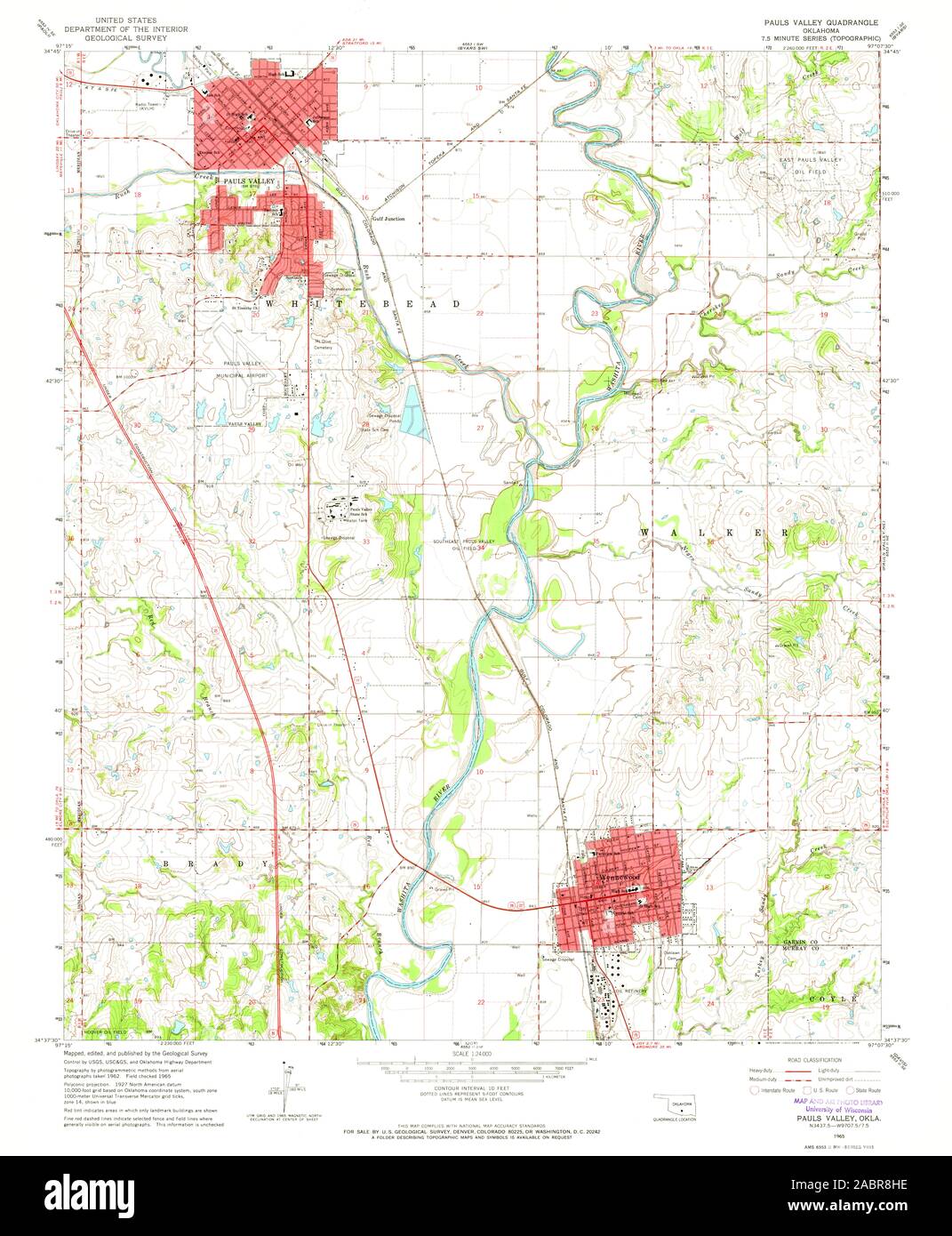
 USGS TOPO Map Oklahoma OK Pauls Valley 20121120 TM il restauro Foto Stockhttps://www.alamy.it/image-license-details/?v=1https://www.alamy.it/usgs-topo-map-oklahoma-ok-pauls-valley-20121120-tm-il-restauro-image334269870.html
RM2ABR8HJ–USGS TOPO Map Oklahoma OK Pauls Valley 20121120 TM il restauro
 Pauls Valley, Garvin County, Stati Uniti, Stati Uniti, Oklahoma, N 34 44' 24''', S 97 13' 20''', MAP, Cartascapes Map pubblicata nel 2024. Esplora Cartascapes, una mappa che rivela i diversi paesaggi, culture ed ecosistemi della Terra. Viaggia attraverso il tempo e lo spazio, scoprendo l'interconnessione del passato, del presente e del futuro del nostro pianeta. Foto Stockhttps://www.alamy.it/image-license-details/?v=1https://www.alamy.it/pauls-valley-garvin-county-stati-uniti-stati-uniti-oklahoma-n-34-44-24-s-97-13-20-map-cartascapes-map-pubblicata-nel-2024-esplora-cartascapes-una-mappa-che-rivela-i-diversi-paesaggi-culture-ed-ecosistemi-della-terra-viaggia-attraverso-il-tempo-e-lo-spazio-scoprendo-l-interconnessione-del-passato-del-presente-e-del-futuro-del-nostro-pianeta-image621430859.html
RM2Y30HB7–Pauls Valley, Garvin County, Stati Uniti, Stati Uniti, Oklahoma, N 34 44' 24''', S 97 13' 20''', MAP, Cartascapes Map pubblicata nel 2024. Esplora Cartascapes, una mappa che rivela i diversi paesaggi, culture ed ecosistemi della Terra. Viaggia attraverso il tempo e lo spazio, scoprendo l'interconnessione del passato, del presente e del futuro del nostro pianeta.
 Sanborn Fire Insurance Map from Pauls Valley, Garvin County, Oklahoma. Foto Stockhttps://www.alamy.it/image-license-details/?v=1https://www.alamy.it/sanborn-fire-insurance-map-from-pauls-valley-garvin-county-oklahoma-image456455750.html
RM2HEH9Y2–Sanborn Fire Insurance Map from Pauls Valley, Garvin County, Oklahoma.
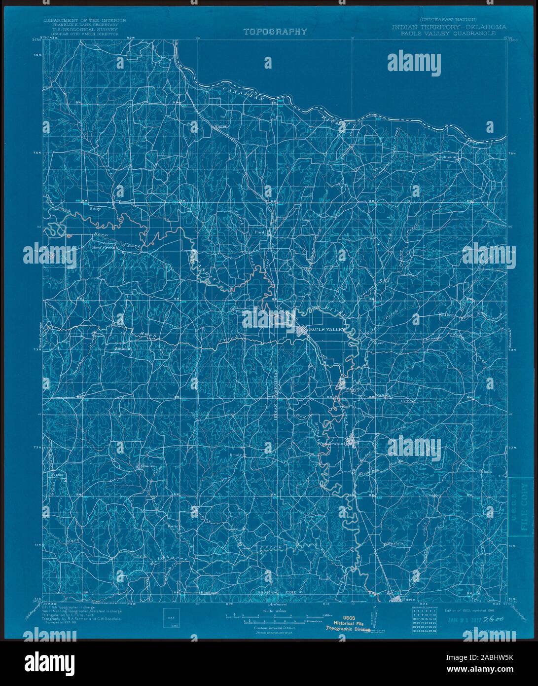
 USGS TOPO Map Oklahoma si Pauls Valley 802567 1902 125000 Il restauro Foto Stockhttps://www.alamy.it/image-license-details/?v=1https://www.alamy.it/usgs-topo-map-oklahoma-si-pauls-valley-802567-1902-125000-il-restauro-image334151227.html
RM2ABHW8B–USGS TOPO Map Oklahoma si Pauls Valley 802567 1902 125000 Il restauro
 Città di Pauls Valley, Garvin County, Stati Uniti, Oklahoma, N 34 44' 15''', S 97 13' 51''', MAP, Cartascapes Map pubblicata nel 2024. Esplora Cartascapes, una mappa che rivela i diversi paesaggi, culture ed ecosistemi della Terra. Viaggia attraverso il tempo e lo spazio, scoprendo l'interconnessione del passato, del presente e del futuro del nostro pianeta. Foto Stockhttps://www.alamy.it/image-license-details/?v=1https://www.alamy.it/citta-di-pauls-valley-garvin-county-stati-uniti-oklahoma-n-34-44-15-s-97-13-51-map-cartascapes-map-pubblicata-nel-2024-esplora-cartascapes-una-mappa-che-rivela-i-diversi-paesaggi-culture-ed-ecosistemi-della-terra-viaggia-attraverso-il-tempo-e-lo-spazio-scoprendo-l-interconnessione-del-passato-del-presente-e-del-futuro-del-nostro-pianeta-image633856656.html
RM2YR6JHM–Città di Pauls Valley, Garvin County, Stati Uniti, Oklahoma, N 34 44' 15''', S 97 13' 51''', MAP, Cartascapes Map pubblicata nel 2024. Esplora Cartascapes, una mappa che rivela i diversi paesaggi, culture ed ecosistemi della Terra. Viaggia attraverso il tempo e lo spazio, scoprendo l'interconnessione del passato, del presente e del futuro del nostro pianeta.
 Sanborn Fire Insurance Map from Pauls Valley, Garvin County, Oklahoma. Foto Stockhttps://www.alamy.it/image-license-details/?v=1https://www.alamy.it/sanborn-fire-insurance-map-from-pauls-valley-garvin-county-oklahoma-image456455747.html
RM2HEH9XY–Sanborn Fire Insurance Map from Pauls Valley, Garvin County, Oklahoma.
 USGS TOPO Map Oklahoma OK Pauls Valley 20091231 TM il restauro Foto Stockhttps://www.alamy.it/image-license-details/?v=1https://www.alamy.it/usgs-topo-map-oklahoma-ok-pauls-valley-20091231-tm-il-restauro-image334269871.html
RM2ABR8HK–USGS TOPO Map Oklahoma OK Pauls Valley 20091231 TM il restauro
 Pauls Valley, Oklahoma, map 1965, 1:24000, United States of America by Timeless Maps, data U.S. Geological Survey Foto Stockhttps://www.alamy.it/image-license-details/?v=1https://www.alamy.it/pauls-valley-oklahoma-map-1965-1-24000-united-states-of-america-by-timeless-maps-data-u-s-geological-survey-image406941747.html
RM2EJ1P9R–Pauls Valley, Oklahoma, map 1965, 1:24000, United States of America by Timeless Maps, data U.S. Geological Survey
 Sanborn Fire Insurance Map from Pauls Valley, Garvin County, Oklahoma. Foto Stockhttps://www.alamy.it/image-license-details/?v=1https://www.alamy.it/sanborn-fire-insurance-map-from-pauls-valley-garvin-county-oklahoma-image456455699.html
RM2HEH9W7–Sanborn Fire Insurance Map from Pauls Valley, Garvin County, Oklahoma.
 USGS TOPO Map Oklahoma si Pauls Valley 802565 1902 125000 Il restauro Foto Stockhttps://www.alamy.it/image-license-details/?v=1https://www.alamy.it/usgs-topo-map-oklahoma-si-pauls-valley-802565-1902-125000-il-restauro-image334151148.html
RM2ABHW5G–USGS TOPO Map Oklahoma si Pauls Valley 802565 1902 125000 Il restauro
 Pauls Valley, Oklahoma, map 1898, 1:125000, United States of America by Timeless Maps, data U.S. Geological Survey Foto Stockhttps://www.alamy.it/image-license-details/?v=1https://www.alamy.it/pauls-valley-oklahoma-map-1898-1-125000-united-states-of-america-by-timeless-maps-data-u-s-geological-survey-image414172521.html
RM2F1R57N–Pauls Valley, Oklahoma, map 1898, 1:125000, United States of America by Timeless Maps, data U.S. Geological Survey
 Sanborn Fire Insurance Map from Pauls Valley, Garvin County, Oklahoma. Foto Stockhttps://www.alamy.it/image-license-details/?v=1https://www.alamy.it/sanborn-fire-insurance-map-from-pauls-valley-garvin-county-oklahoma-image456455710.html
RM2HEH9WJ–Sanborn Fire Insurance Map from Pauls Valley, Garvin County, Oklahoma.
 USGS TOPO Map Oklahoma OK Pauls Valley NE 20121120 TM il restauro Foto Stockhttps://www.alamy.it/image-license-details/?v=1https://www.alamy.it/usgs-topo-map-oklahoma-ok-pauls-valley-ne-20121120-tm-il-restauro-image334270056.html
RM2ABR8T8–USGS TOPO Map Oklahoma OK Pauls Valley NE 20121120 TM il restauro
 Pauls Valley, Oklahoma, map 1986, 1:100000, United States of America by Timeless Maps, data U.S. Geological Survey Foto Stockhttps://www.alamy.it/image-license-details/?v=1https://www.alamy.it/pauls-valley-oklahoma-map-1986-1-100000-united-states-of-america-by-timeless-maps-data-u-s-geological-survey-image406941753.html
RM2EJ1PA1–Pauls Valley, Oklahoma, map 1986, 1:100000, United States of America by Timeless Maps, data U.S. Geological Survey
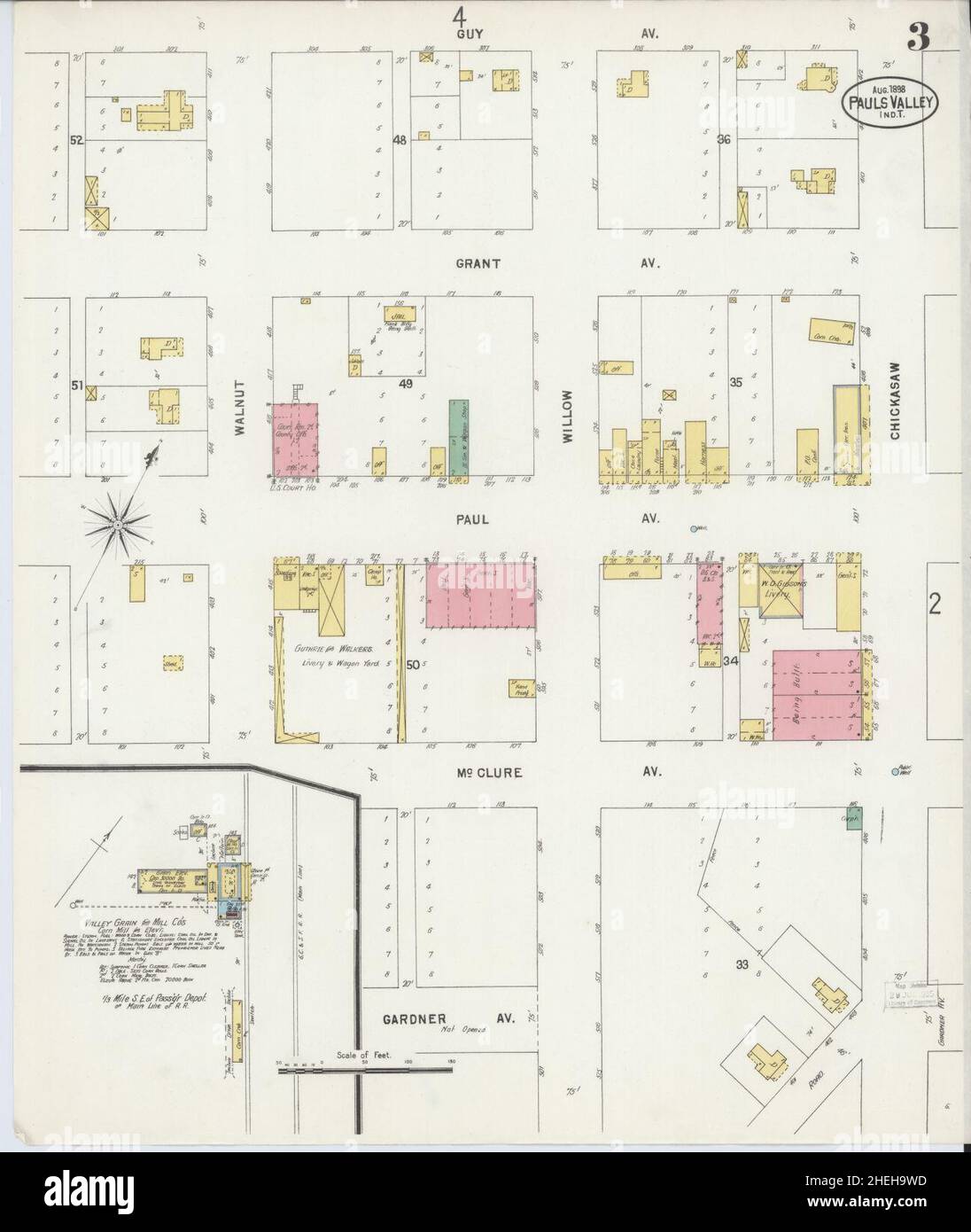
 Sanborn Fire Insurance Map from Pauls Valley, Garvin County, Oklahoma. Foto Stockhttps://www.alamy.it/image-license-details/?v=1https://www.alamy.it/sanborn-fire-insurance-map-from-pauls-valley-garvin-county-oklahoma-image456455705.html
RM2HEH9WD–Sanborn Fire Insurance Map from Pauls Valley, Garvin County, Oklahoma.
 USGS TOPO Map Oklahoma OK Pauls Valley 20121120 TM restauro invertito Foto Stockhttps://www.alamy.it/image-license-details/?v=1https://www.alamy.it/usgs-topo-map-oklahoma-ok-pauls-valley-20121120-tm-restauro-invertito-image334269867.html
RM2ABR8HF–USGS TOPO Map Oklahoma OK Pauls Valley 20121120 TM restauro invertito
 Pauls Valley, Oklahoma, map 1986, 1:100000, United States of America by Timeless Maps, data U.S. Geological Survey Foto Stockhttps://www.alamy.it/image-license-details/?v=1https://www.alamy.it/pauls-valley-oklahoma-map-1986-1-100000-united-states-of-america-by-timeless-maps-data-u-s-geological-survey-image406941765.html
RM2EJ1PAD–Pauls Valley, Oklahoma, map 1986, 1:100000, United States of America by Timeless Maps, data U.S. Geological Survey
 Sanborn Fire Insurance Map from Pauls Valley, Garvin County, Oklahoma. Foto Stockhttps://www.alamy.it/image-license-details/?v=1https://www.alamy.it/sanborn-fire-insurance-map-from-pauls-valley-garvin-county-oklahoma-image456455706.html
RM2HEH9WE–Sanborn Fire Insurance Map from Pauls Valley, Garvin County, Oklahoma.
 USGS TOPO Map Oklahoma OK Pauls Valley 707160 1986 100000 Il restauro Foto Stockhttps://www.alamy.it/image-license-details/?v=1https://www.alamy.it/usgs-topo-map-oklahoma-ok-pauls-valley-707160-1986-100000-il-restauro-image334269982.html
RM2ABR8NJ–USGS TOPO Map Oklahoma OK Pauls Valley 707160 1986 100000 Il restauro
 Pauls Valley, Oklahoma, map 1902, 1:125000, United States of America by Timeless Maps, data U.S. Geological Survey Foto Stockhttps://www.alamy.it/image-license-details/?v=1https://www.alamy.it/pauls-valley-oklahoma-map-1902-1-125000-united-states-of-america-by-timeless-maps-data-u-s-geological-survey-image414172475.html
RM2F1R563–Pauls Valley, Oklahoma, map 1902, 1:125000, United States of America by Timeless Maps, data U.S. Geological Survey
 Sanborn Fire Insurance Map from Pauls Valley, Garvin County, Oklahoma. Foto Stockhttps://www.alamy.it/image-license-details/?v=1https://www.alamy.it/sanborn-fire-insurance-map-from-pauls-valley-garvin-county-oklahoma-image456455622.html
RM2HEH9PE–Sanborn Fire Insurance Map from Pauls Valley, Garvin County, Oklahoma.
 USGS TOPO Map Oklahoma OK Pauls Valley 802360 1898 125000 Il restauro Foto Stockhttps://www.alamy.it/image-license-details/?v=1https://www.alamy.it/usgs-topo-map-oklahoma-ok-pauls-valley-802360-1898-125000-il-restauro-image334269985.html
RM2ABR8NN–USGS TOPO Map Oklahoma OK Pauls Valley 802360 1898 125000 Il restauro
 Pauls Valley, Oklahoma, map 1965, 1:24000, United States of America by Timeless Maps, data U.S. Geological Survey Foto Stockhttps://www.alamy.it/image-license-details/?v=1https://www.alamy.it/pauls-valley-oklahoma-map-1965-1-24000-united-states-of-america-by-timeless-maps-data-u-s-geological-survey-image406941763.html
RM2EJ1PAB–Pauls Valley, Oklahoma, map 1965, 1:24000, United States of America by Timeless Maps, data U.S. Geological Survey
 Sanborn Fire Insurance Map from Pauls Valley, Garvin County, Oklahoma. Foto Stockhttps://www.alamy.it/image-license-details/?v=1https://www.alamy.it/sanborn-fire-insurance-map-from-pauls-valley-garvin-county-oklahoma-image456455712.html
RM2HEH9WM–Sanborn Fire Insurance Map from Pauls Valley, Garvin County, Oklahoma.
 USGS TOPO Map Oklahoma OK Pauls Valley 20091231 TM restauro invertito Foto Stockhttps://www.alamy.it/image-license-details/?v=1https://www.alamy.it/usgs-topo-map-oklahoma-ok-pauls-valley-20091231-tm-restauro-invertito-image334269874.html
RM2ABR8HP–USGS TOPO Map Oklahoma OK Pauls Valley 20091231 TM restauro invertito
 USGS TOPO Map Oklahoma si Pauls Valley 802565 1902 125000 Restauro invertito Foto Stockhttps://www.alamy.it/image-license-details/?v=1https://www.alamy.it/usgs-topo-map-oklahoma-si-pauls-valley-802565-1902-125000-restauro-invertito-image334151151.html
RM2ABHW5K–USGS TOPO Map Oklahoma si Pauls Valley 802565 1902 125000 Restauro invertito
 USGS TOPO Map Oklahoma OK Pauls Valley NE 20100130 TM il restauro Foto Stockhttps://www.alamy.it/image-license-details/?v=1https://www.alamy.it/usgs-topo-map-oklahoma-ok-pauls-valley-ne-20100130-tm-il-restauro-image334270063.html
RM2ABR8TF–USGS TOPO Map Oklahoma OK Pauls Valley NE 20100130 TM il restauro
 USGS TOPO Map Oklahoma OK Pauls Valley 706545 1965 24000 Restauro Foto Stockhttps://www.alamy.it/image-license-details/?v=1https://www.alamy.it/usgs-topo-map-oklahoma-ok-pauls-valley-706545-1965-24000-restauro-image334269872.html
RM2ABR8HM–USGS TOPO Map Oklahoma OK Pauls Valley 706545 1965 24000 Restauro
 USGS TOPO Map Oklahoma si Pauls Valley 802567 1902 125000 Restauro invertito Foto Stockhttps://www.alamy.it/image-license-details/?v=1https://www.alamy.it/usgs-topo-map-oklahoma-si-pauls-valley-802567-1902-125000-restauro-invertito-image334151192.html
RM2ABHW74–USGS TOPO Map Oklahoma si Pauls Valley 802567 1902 125000 Restauro invertito
 USGS TOPO Map Oklahoma OK Pauls Valley 706546 1965 24000 Restauro Foto Stockhttps://www.alamy.it/image-license-details/?v=1https://www.alamy.it/usgs-topo-map-oklahoma-ok-pauls-valley-706546-1965-24000-restauro-image334269866.html
RM2ABR8HE–USGS TOPO Map Oklahoma OK Pauls Valley 706546 1965 24000 Restauro
 USGS TOPO Map Oklahoma OK Pauls Valley 707159 1986 100000 Il restauro Foto Stockhttps://www.alamy.it/image-license-details/?v=1https://www.alamy.it/usgs-topo-map-oklahoma-ok-pauls-valley-707159-1986-100000-il-restauro-image334269977.html
RM2ABR8ND–USGS TOPO Map Oklahoma OK Pauls Valley 707159 1986 100000 Il restauro
 USGS TOPO Map Oklahoma OK Pauls Valley 802361 1902 125000 Il restauro Foto Stockhttps://www.alamy.it/image-license-details/?v=1https://www.alamy.it/usgs-topo-map-oklahoma-ok-pauls-valley-802361-1902-125000-il-restauro-image334270017.html
RM2ABR8PW–USGS TOPO Map Oklahoma OK Pauls Valley 802361 1902 125000 Il restauro
 USGS TOPO Map Oklahoma OK Pauls Valley 707159 1986 100000 Restauro invertito Foto Stockhttps://www.alamy.it/image-license-details/?v=1https://www.alamy.it/usgs-topo-map-oklahoma-ok-pauls-valley-707159-1986-100000-restauro-invertito-image334270027.html
RM2ABR8R7–USGS TOPO Map Oklahoma OK Pauls Valley 707159 1986 100000 Restauro invertito
 USGS TOPO Map Oklahoma OK Pauls Valley 707160 1986 100000 Restauro invertito Foto Stockhttps://www.alamy.it/image-license-details/?v=1https://www.alamy.it/usgs-topo-map-oklahoma-ok-pauls-valley-707160-1986-100000-restauro-invertito-image334269979.html
RM2ABR8NF–USGS TOPO Map Oklahoma OK Pauls Valley 707160 1986 100000 Restauro invertito
 USGS TOPO Map Oklahoma OK Pauls Valley NE 706548 1965 24000 Restauro Foto Stockhttps://www.alamy.it/image-license-details/?v=1https://www.alamy.it/usgs-topo-map-oklahoma-ok-pauls-valley-ne-706548-1965-24000-restauro-image334270098.html
RM2ABR8WP–USGS TOPO Map Oklahoma OK Pauls Valley NE 706548 1965 24000 Restauro
 USGS TOPO Map Oklahoma OK Pauls Valley 802360 1898 125000 Restauro invertito Foto Stockhttps://www.alamy.it/image-license-details/?v=1https://www.alamy.it/usgs-topo-map-oklahoma-ok-pauls-valley-802360-1898-125000-restauro-invertito-image334269972.html
RM2ABR8N8–USGS TOPO Map Oklahoma OK Pauls Valley 802360 1898 125000 Restauro invertito
 USGS TOPO Map Oklahoma OK Pauls Valley 706546 1965 24000 Restauro invertito Foto Stockhttps://www.alamy.it/image-license-details/?v=1https://www.alamy.it/usgs-topo-map-oklahoma-ok-pauls-valley-706546-1965-24000-restauro-invertito-image334269875.html
RM2ABR8HR–USGS TOPO Map Oklahoma OK Pauls Valley 706546 1965 24000 Restauro invertito
 USGS TOPO Map Oklahoma OK Pauls Valley NE 20100130 TM restauro invertito Foto Stockhttps://www.alamy.it/image-license-details/?v=1https://www.alamy.it/usgs-topo-map-oklahoma-ok-pauls-valley-ne-20100130-tm-restauro-invertito-image334270035.html
RM2ABR8RF–USGS TOPO Map Oklahoma OK Pauls Valley NE 20100130 TM restauro invertito
 USGS TOPO Map Oklahoma OK Pauls Valley 802361 1902 125000 Restauro invertito Foto Stockhttps://www.alamy.it/image-license-details/?v=1https://www.alamy.it/usgs-topo-map-oklahoma-ok-pauls-valley-802361-1902-125000-restauro-invertito-image334270029.html
RM2ABR8R9–USGS TOPO Map Oklahoma OK Pauls Valley 802361 1902 125000 Restauro invertito
 USGS TOPO Map Oklahoma OK Pauls Valley NE 706547 1965 24000 Restauro Foto Stockhttps://www.alamy.it/image-license-details/?v=1https://www.alamy.it/usgs-topo-map-oklahoma-ok-pauls-valley-ne-706547-1965-24000-restauro-image334270060.html
RM2ABR8TC–USGS TOPO Map Oklahoma OK Pauls Valley NE 706547 1965 24000 Restauro
 USGS TOPO Map Oklahoma OK Pauls Valley 706545 1965 24000 Restauro invertito Foto Stockhttps://www.alamy.it/image-license-details/?v=1https://www.alamy.it/usgs-topo-map-oklahoma-ok-pauls-valley-706545-1965-24000-restauro-invertito-image334269869.html
RM2ABR8HH–USGS TOPO Map Oklahoma OK Pauls Valley 706545 1965 24000 Restauro invertito
 USGS TOPO Map Oklahoma OK Pauls Valley NE 20121120 TM restauro invertito Foto Stockhttps://www.alamy.it/image-license-details/?v=1https://www.alamy.it/usgs-topo-map-oklahoma-ok-pauls-valley-ne-20121120-tm-restauro-invertito-image334270061.html
RM2ABR8TD–USGS TOPO Map Oklahoma OK Pauls Valley NE 20121120 TM restauro invertito
 USGS TOPO Map Oklahoma OK Pauls Valley NE 706548 1965 24000 Restauro invertito Foto Stockhttps://www.alamy.it/image-license-details/?v=1https://www.alamy.it/usgs-topo-map-oklahoma-ok-pauls-valley-ne-706548-1965-24000-restauro-invertito-image334270086.html
RM2ABR8WA–USGS TOPO Map Oklahoma OK Pauls Valley NE 706548 1965 24000 Restauro invertito
 USGS TOPO Map Oklahoma OK Pauls Valley NE 706547 1965 24000 Restauro invertito Foto Stockhttps://www.alamy.it/image-license-details/?v=1https://www.alamy.it/usgs-topo-map-oklahoma-ok-pauls-valley-ne-706547-1965-24000-restauro-invertito-image334270058.html
RM2ABR8TA–USGS TOPO Map Oklahoma OK Pauls Valley NE 706547 1965 24000 Restauro invertito